

 Kris Crismundo
The southern part of Luzon has many wonders to offer: mountains, volcanoes, beaches, falls, rivers, and lakes, among others. Name any nature escapade you want, and Southern Luzon has a lot to offer. One of these many wonders of Southern Luzon is Mt. Daraitan in Tanay, Rizal.

Mt Daraitan in Tanay Rizal
It’s obvious that going to Mt. Daraitan means a hiking activity, but this 739-meter-above-sea-level (MASL) mountain is also a good spot for caving or spelunking, rock climbing, river swimming, and camping.
There are two main campsites in Mt. Daraitan. First is right at the summit, but it can accommodate only four to five tents. Second is in Tinipak Riverside, which can hold up to 25 tents.
Mt. Daraitan can be climbed by day hike, but it will be hard to compress all activities in a single day.
So, to enjoy the wonders of Mt. Daraitan, my group and I allotted two days for all the activities on this wonderful mountain.
You may also follow our itinerary whenever you plan to hit this mountain.

Day 1: Tinipak River adventure
Coming from Metro Manila, take a jeepney or an SUV Express to Tanay in front of Starmall on Shaw Blvd. This will be an hour-and-a-half ride to Tanay market. From Tanay market, you can take a tricycle to Barangay Daraitan, with an estimated travel time of 2 hours.
The jump-off point would be its Barangay Hall, where there will be an environmental fee of PhP20 per person and a tour guide fee of PhP1,250 per group for overnight activities or PhP550 for a day hike.
The tourism cluster of Brgy. Daraitan requires tourists to have a local guide for safety reasons. A guide can facilitate up to 10 persons.
Since we chose to do a two-day activity, we first went on the Tinipak River adventure.
Our Day 1 activity involved a one-hour walk to the campsite in Tinipak River. Just walking to the camping site, you’ll surely be amazed by the rock formations, cleanliness, and the relaxing sound of water rushing in the river.
Going to the campsite will also involve minor rock climbing.
After setting up the tents, we then hit the cave just across our campsite. It was a 15- to 25-minute walk inside the cave (depending on speed and photo opportunities) until we reached a Mother Earth-made Jacuzzi with 15-degree-Celsius water, where we could swim and spelunk at the same time! Then we continue swimming in the river.
After a day of jam-packed wandering, it’s best to sleep early and prepare yourselves for the main activity the next day, which is climbing Mt. Daraitan.
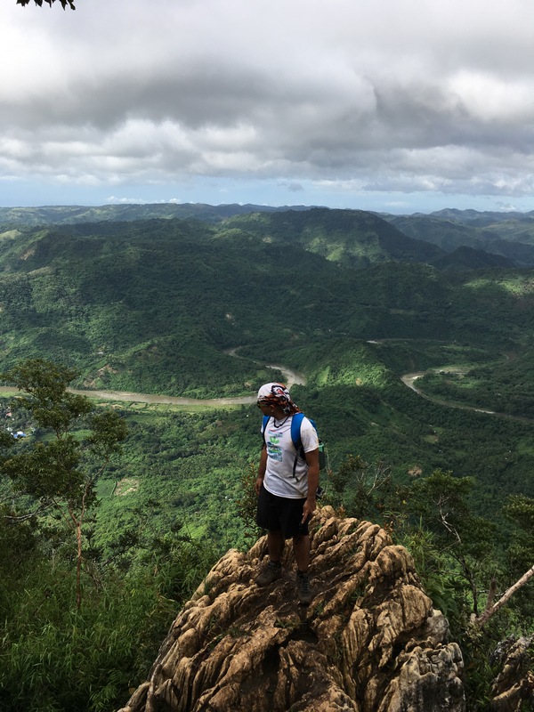
Day 2: Mt. Daraitan hike
It’s best to start the Mt. Daraitan hike at the crack of dawn since it’s hard to see the trail when it is still dark.
Climbing Mt. Daraitan will require two and a half to four hours of hiking until reaching the summit.
I must warn you, this is a tough hike. Unlike other mountains, which have ascending and descending trails and mostly require walking, almost 90 percent of your Mt. Daraitan experience will be climbing.
Good thing that Mt. Daraitan is a forest-type mountain; you’ll be protected from sunlight.
But this tough experience is all worth it when you reach the summit. Be ready to amaze yourself with the view of the Sierra Madre Mountains, Daraitan River, and Laguna de Bay.
Since 2015 is Visit Philippines Year, why not wander around Mt. Daraitan—one of the wonders of Southern Luzon?
Frequently Asked Questions (FAQ) About Mt. Daraitan in Tanay, Rizal
1. Where is Mt. Daraitan located?
Mt. Daraitan is located in Barangay Daraitan, in the municipality of Tanay, Rizal, on the eastern edge of the Sierra Madre Mountain Range. The mountain sits near the boundary of Rizal and General Nakar, Quezon, making it one of the closest wilderness destinations to Metro Manila. Its convenient location—approximately 2.5 to 3.5 hours from the capital—has made it one of the most popular hiking destinations for day trips and weekend adventures. Aside from the mountain itself, the area is surrounded by lush forests, pristine rivers, dramatic limestone formations, and scenic countryside, making it an excellent destination for outdoor enthusiasts.
2. How high is Mt. Daraitan?
Mt. Daraitan stands approximately 739 meters (2,425 feet) above sea level. While it is classified as a minor mountain in terms of elevation, it should not be underestimated. The trail features steep ascents, rocky limestone sections, and slippery paths that require careful footing. Reaching the summit rewards hikers with spectacular panoramic views of the Sierra Madre Mountains, lush valleys, winding rivers, and neighboring peaks. On clear mornings, visitors may even witness a breathtaking sea of clouds covering the landscape below.
3. Is Mt. Daraitan suitable for beginners?
Yes, Mt. Daraitan is often recommended for physically fit beginners, but it is considered more challenging than many first-time hiking destinations. The mountain has a moderate difficulty level, featuring several steep climbs, rocky trails, and muddy sections, especially during the rainy season. First-time hikers should prepare by doing light cardio exercises before their trip and wearing proper hiking shoes with excellent traction. Beginners are encouraged to hike with experienced companions or local guides who are familiar with the terrain.
4. How long does it take to hike Mt. Daraitan?
The ascent to the summit usually takes between two and four hours, depending on your fitness level, trail conditions, and the number of rest stops. Descending generally takes another two to three hours. Many visitors combine the hike with a visit to Tinipak River, making the entire adventure a full-day excursion lasting 8 to 10 hours from registration to completion.
5. What makes Mt. Daraitan famous?
Mt. Daraitan is renowned for combining an exciting mountain climb with some of Rizal’s most stunning natural attractions. The destination is famous for its panoramic summit views, towering limestone cliffs, lush forests, caves, and the crystal-clear Tinipak River, often regarded as one of the cleanest rivers in the Philippines. Visitors love the combination of hiking, swimming, cave exploration, and photography, making it one of the country’s most rewarding outdoor destinations near Metro Manila.
6. What is the Tinipak River, and why should I visit it?
Tinipak River is one of the biggest attractions in Barangay Daraitan. Known for its emerald-green waters and enormous white marble-like limestone boulders, the river offers a refreshing place to cool off after the hike. Visitors can swim, explore nearby caves, rent bamboo rafts, enjoy riverside picnics, or simply admire the spectacular rock formations sculpted by nature over thousands of years. Many travelers consider Tinipak River just as impressive as the mountain itself.
7. Do I need a tour guide to hike Mt. Daraitan?
Yes. Hiring a registered local guide is generally required before hiking Mt. Daraitan. Guides are assigned at the Barangay Hall registration area and are familiar with the mountain’s trails, weather conditions, and safety procedures. Hiring local guides also supports the community’s livelihoods while ensuring that visitors practice responsible and sustainable tourism.
8. When is the best time to visit Mt. Daraitan?
The ideal time to visit is during the dry season, from November to April. During these months, the trails are generally safer and less muddy and offer clearer views from the summit. Hiking during the rainy season between May and October is still possible, but slippery trails, swollen rivers, and sudden weather changes can make the trek significantly more difficult and potentially hazardous. Always check the weather forecast before your trip.
9. What should I bring for the hike?
Essential items include sturdy hiking shoes, lightweight and moisture-wicking clothing, plenty of drinking water, trail snacks, sun protection, a rain jacket, a first aid kit, insect repellent, gloves for rocky sections, a power bank, and a waterproof bag for electronics. If you plan to swim in Tinipak River, pack extra clothes, a towel, and waterproof footwear for river crossings.
10. Can I visit Mt. Daraitan and Tinipak River in one day?
Yes. Most visitors complete both attractions within a single day. Many hikers begin registration before sunrise, climb to the summit in the morning, descend by late morning or early afternoon, and spend several hours relaxing and swimming at Tinipak River before returning to Manila. This itinerary offers an excellent combination of adventure and relaxation without requiring an overnight stay.
11. Are there accommodations near Mt. Daraitan?
Yes. Visitors can choose from homestays, guesthouses, camping areas, and simple lodges within Barangay Daraitan. Nearby accommodations in Tanay also offer comfortable rooms for travelers who wish to explore other attractions such as Daranak Falls, Batlag Falls, Masungi Georeserve, and Calinawan Cave during a weekend getaway.
12. Is camping allowed at Mt. Daraitan?
Yes. Camping is permitted in designated camping areas managed by the local community. Many outdoor enthusiasts choose to stay overnight to experience sunrise hikes, stargazing, and the peaceful atmosphere of the Sierra Madre foothills. Campers should bring proper camping equipment, observe Leave No Trace principles, and follow all local regulations.
13. Is Mt. Daraitan safe for families and children?
The hike itself is better suited to teenagers and adults with reasonable fitness levels due to its steep, rocky terrain. However, families with young children can still enjoy Tinipak River, which has calmer areas for swimming and sightseeing. Parents should closely supervise children, especially near cliffs, rivers, and rocky sections.
14. What wildlife and natural scenery can visitors expect?
Mt. Daraitan is part of the biologically rich Sierra Madre Mountain Range. Along the trail, hikers may encounter native trees, colorful butterflies, birds, insects, and various tropical plants. The mountain also features impressive limestone cliffs, dense forests, caves, rivers, and dramatic rock formations that make every section of the hike visually rewarding.
15. Why is Mt. Daraitan considered one of the best hiking destinations near Metro Manila?
Mt. Daraitan offers a complete outdoor adventure within a few hours of the city. Visitors can experience a moderately challenging hike, breathtaking summit views, crystal-clear rivers, cave exploration, limestone landscapes, and warm local hospitality—all in one destination. Its accessibility, natural beauty, and variety of activities make it one of the most rewarding hiking destinations in Rizal and among the top weekend escapes for nature lovers in the Philippines.
Follow and subscribe to OutofTownBlog.com on Facebook , Twitter, Instagram, Pinterest, and YouTube for more Travel-related updates.
Read:


