

 Melo Villareal
20 Stunning Places to Visit in the United States
The United States offers an extraordinary range of beautiful destinations, from towering mountains and colorful desert landscapes to tropical beaches, historic cities, and charming coastal communities. Each region has its own scenery, architecture, and seasonal attractions, making the country suitable for many different kinds of trips.

20 Most Beautiful Places in the U.S.
The most beautiful places in the U.S. include natural wonders like the Grand Canyon and Yosemite National Park, as well as urban destinations such as Chicago and New Orleans. You can explore rugged coastlines, walk through historic neighborhoods, visit dramatic geological formations, or enjoy scenic drives through some of the country’s most remarkable landscapes.
This guide highlights 20 beautiful destinations across different U.S. states. Each entry covers the scenery, notable attractions, ideal visiting seasons, photography opportunities, and practical ways to get there. The selection includes well-known landmarks and less familiar places, giving you a broad look at the country’s natural beauty and cultural character.
1. Grand Canyon National Park, Arizona
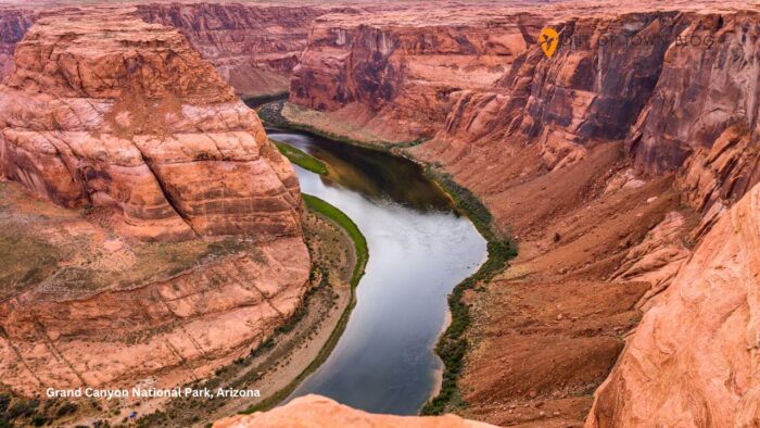
The Grand Canyon is one of the United States’ most recognizable natural landscapes. Its immense scale, layered rock formations, and changing colors make it a remarkable destination for sightseeing and landscape photography. Carved by the Colorado River over millions of years, the canyon stretches across northern Arizona and features deep ravines, steep cliffs, and expansive desert views.
The South Rim is the most accessible starting point for many visitors. Grand Canyon Village offers several overlooks, visitor facilities, walking paths, and access to the Rim Trail. Popular viewpoints include Mather Point, Yavapai Point, and Desert View, where the canyon’s rock layers become especially striking in changing light.
The North Rim offers a quieter experience, with forested surroundings and a different perspective of the canyon. However, it operates seasonally and is more remote than the South Rim. The area suits travelers who can plan around its shorter operating season.
Spring and fall are generally comfortable seasons for exploring the canyon rim. April through May and September through October often offer pleasant daytime conditions, though temperatures vary widely with elevation. Summer brings long days but can produce dangerous heat, particularly below the rim. Winter may bring snow and icy conditions.
For photography, look for overlooks that reveal multiple layers of the canyon rather than focusing only on the nearest cliff edge. Sunrise and sunset can bring out red, orange, and purple tones in the rock formations.
Getting there: Flagstaff and Phoenix are common gateway cities for the South Rim, with rental cars, road connections, and some seasonal or scheduled transport options available. The North Rim requires a longer drive and careful seasonal planning.
Travel tip: Bring water, sun protection, and sturdy footwear. Even short walks along the rim can involve uneven surfaces and exposure to changing weather.
2. Yosemite National Park, California
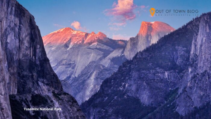
Yosemite National Park is known for its granite cliffs, waterfalls, giant sequoias, and forested valleys. Located in California’s Sierra Nevada mountains, the park combines dramatic rock formations with meadows, rivers, and alpine scenery. Its varied landscapes make it one of the most beautiful places in the U.S. for nature photography.
Yosemite Valley is the main sightseeing area. El Capitan rises above the valley floor, while Half Dome dominates the distant skyline. Yosemite Falls, one of the park’s most famous waterfalls, is especially impressive when spring and early-summer snowmelt increases the flow.
Other notable areas include Tunnel View, which provides a sweeping view of Yosemite Valley, and Mariposa Grove, home to giant sequoias. Tuolumne Meadows offers a different landscape of high-elevation meadows, granite domes, and mountain streams when its seasonal road access is available.
Spring is one of the best seasons for waterfalls, while summer provides access to many higher-elevation areas. September and early October bring cooler weather and fewer visitors than peak summer. Autumn colors vary from year to year, and winter transforms parts of the park with snow and quieter scenery.
For photography, Tunnel View offers a classic panorama, while valley meadows let you capture granite cliffs reflected in the Merced River. A telephoto lens can help isolate waterfalls and rock details, while a wide-angle lens works well for the larger landscape.
Getting there: You can reach Yosemite by car from cities such as San Francisco and Sacramento, though driving times vary by entrance and traffic. Regional airports and public transportation connections can support trips, but the final journey requires careful planning.
Travel tip: Check road access and any required entry arrangements before departure, particularly for peak-season visits and trips to high-elevation areas.
3. Na Pali Coast, Kauai, Hawaii
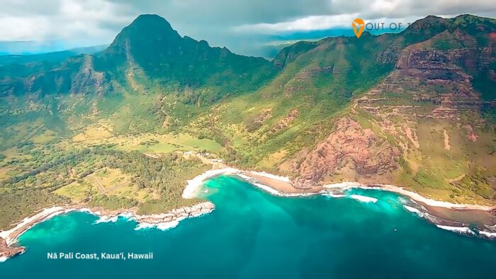
The Na Pali Coast on Kauai’s northwestern shore is one of the most visually dramatic coastal landscapes in the United States. Its steep green cliffs rise above the Pacific Ocean, creating ridges, valleys, and narrow beaches that are difficult to reach by road. After rainfall, waterfalls descend from the mountains, adding to the area’s tropical scenery.
The coastline is especially striking because of the contrast between emerald-green vegetation, dark volcanic rock, and deep-blue ocean water. Parts of the coast are protected and remote, which helps preserve its rugged character.
Visitors can take in the landscape from designated viewpoints and accessible coastal areas, while more adventurous travelers can explore permitted hiking routes or take guided boat excursions when conditions allow. Authorized helicopter tours can offer aerial perspectives that reveal the scale of the ridges and hidden valleys, though weather can affect visibility and availability.
The drier months, generally April through October, often provide favorable conditions for outdoor sightseeing. However, Kauai remains tropical, and rain can fall year-round. Winter may bring larger ocean swells and rougher conditions along exposed sections of the coast.
Photography opportunities are particularly strong when sunlight illuminates the green ridges against the ocean. Cloud cover can also create atmospheric images, especially when mist settles around the higher cliffs. For coastal photography, protect your equipment from salt spray and sudden rain.
Getting there: Fly into Lihue Airport on Kauai, then use a rental car, taxi, or organized excursion to reach accessible viewpoints and departure points. Some sections of the coastline are not accessible by road.
Travel tip: Ocean and trail conditions can change quickly. Choose viewpoints and excursions that match your fitness level and follow current safety guidance.
4. Kenai Fjords National Park, Alaska
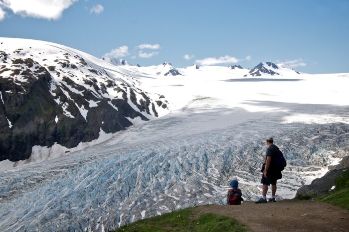
Kenai Fjords National Park showcases Alaska’s rugged coastal scenery, including glaciers, steep mountains, rocky shorelines, and cold Pacific waters. Near Seward on the Kenai Peninsula, the park offers a dramatic mix of ice, forest, and ocean. It is one of the most distinctive destinations for travelers seeking Alaska’s wild landscapes.
The Exit Glacier area provides a land-based introduction to the park. Visitors can see glacial ice and learn about how the surrounding landscape changes as glaciers retreat. Other park experiences focus on the coastline, where boat excursions may pass tidewater glaciers, rocky islands, and habitats used by seabirds and marine mammals.
The scenery changes throughout the year. Summer, especially June through August, is the main season for many visitor services and boat trips. Long daylight hours allow more time for sightseeing, while wildlife activity can make coastal excursions particularly rewarding. Shoulder-season travel may offer quieter conditions, but services and access can be limited.
For photography, bring layers and weather protection because coastal conditions can be cold even in summer. A telephoto lens helps capture distant wildlife and details of glaciers. Wide-angle images can capture the scale of mountains meeting the sea.
Getting there: Seward is the principal gateway for many park visits. Travelers can reach the town by road from Anchorage or use seasonal rail and organized transportation services. Boat excursions depart from the Seward area when operating conditions permit.
Travel tip: Allow flexibility in your schedule. Rain, wind, and sea conditions can affect visibility and coastal excursion operations.
5. Oregon Coast, Oregon
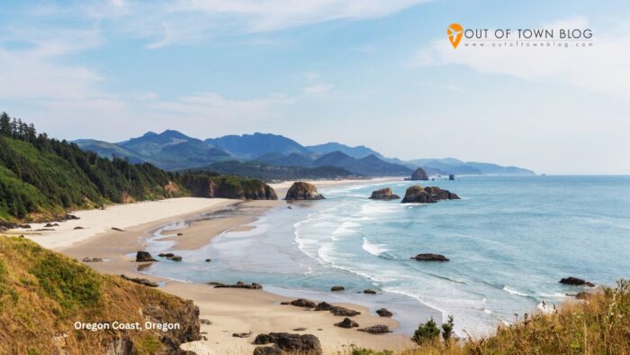
The Oregon Coast is known for its rugged headlands, long beaches, sea stacks, forested cliffs, and historic coastal communities. Unlike tropical beach destinations, this stretch of the Pacific coastline has a cooler atmosphere and dramatic scenery shaped by wind, waves, and changing weather.
Cannon Beach is one of the best-known stops, thanks to Haystack Rock, a prominent sea stack rising from the shoreline. Other coastal areas feature sandy beaches, rocky tide pools, coastal forests, and viewpoints overlooking the Pacific. Small coastal towns offer places to stop for meals, local shopping, and ocean views.
Spring brings fresh green vegetation and variable weather. Summer usually offers more comfortable conditions for beach walks and coastal drives, although fog can obscure ocean views. Fall can bring dramatic skies and changing light, while winter storms create powerful surf and a more rugged atmosphere.
The coast is especially photogenic when low clouds frame the headlands or when waves break around offshore rock formations. For tide-pool photography, check tide tables and observe posted guidance. Keep a safe distance from the water, since unexpectedly large waves can reach farther up the beach than expected.
Getting there: Portland is a common gateway to the northern coast, and a rental car offers the most flexibility. You can reach other coastal sections via regional airports and highway connections. Some routes have public transportation, but service varies by community.
Travel tip: Pack a waterproof outer layer even during summer. Coastal temperatures and wind can change quickly, and beaches may feel much colder than inland areas.
6. Glacier National Park, Montana

Glacier National Park features alpine lakes, rugged peaks, deep valleys, and forests that cover much of northwestern Montana. Its dramatic scenery includes steep ridgelines, waterfalls, wildflower meadows, and clear lakes framed by mountains.
The Going-to-the-Sun Road is one of the park’s most famous scenic routes. It crosses mountainous terrain and offers sweeping views of valleys, cliffs, and alpine landscapes. Lake McDonald is another highlight, known for its clear water and colorful shoreline stones. Higher elevations offer a different perspective, with exposed rock, snowfields, and mountain vegetation.
Summer is the main season for accessing many areas, especially from July through September. Snow can affect mountain roads and trails into early summer, while fall brings cooler weather and changing foliage at lower elevations. Spring visits may offer waterfalls and fewer crowds, but some facilities and roads may not yet be open.
For photography, Lake McDonald is a strong location for mountain reflections when the water is calm. Higher viewpoints provide broad panoramas, while meadows offer opportunities to photograph wildflowers during their seasonal bloom.
Getting there: You can reach Glacier National Park via regional airports near Kalispell and other communities in northwestern Montana. Rental cars and organized transport are common options, although access to specific areas varies seasonally.
Travel tip: Check current road conditions and vehicle access requirements before traveling. Mountain weather can change rapidly, even during summer.
7. Santa Fe, New Mexico

Santa Fe combines desert scenery, adobe architecture, historic streets, and a distinctive Southwestern artistic culture. Set against the Sangre de Cristo Mountains, the city’s visual identity is shaped by earth-toned buildings, traditional courtyards, galleries, and churches. It is one of the most distinctive urban destinations in the United States.
The historic center is a great place to start. Shops, restaurants, and historic buildings surround the Santa Fe Plaza, while the Palace of the Governors reflects the city’s long history. The Cathedral Basilica of St. Francis of Assisi and the Loretto Chapel are notable architectural landmarks. Art galleries and museums add another dimension to the city’s cultural landscape.
Spring and fall are particularly comfortable seasons for exploring the city on foot. Summer brings warmer weather and a monsoon season that can produce dramatic afternoon skies. Winter may bring snow to the surrounding mountains, creating a contrast between the city’s adobe architecture and the higher elevations.
Photography opportunities include adobe facades, narrow historic streets, mountain backdrops, and courtyards. Early morning light can emphasize the warm tones of traditional buildings, while changing cloud formations create striking views of the surrounding landscape.
Getting there: Santa Fe has a regional airport, while Albuquerque International Sunport offers additional flight options about an hour or more away by road, depending on traffic. You can drive, use shuttle services, or take regional transport connections.
Travel tip: Santa Fe sits at a relatively high elevation. Give yourself time to adjust, especially if you plan to explore the surrounding mountains.
8. Great Sand Dunes National Park and Preserve, Colorado
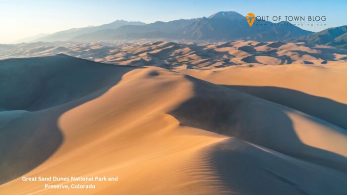
Great Sand Dunes National Park and Preserve features enormous dunes set against the Sangre de Cristo Mountains in southern Colorado. The contrast between golden sand, dark mountain ridges, and broad skies creates a landscape that looks very different from the state’s better-known alpine scenery.
The main dune field is the park’s central attraction. Visitors can walk across the sand, climb selected dunes, and view the landscape from different elevations. Medano Creek may form a seasonal stream near the base of the dunes during snowmelt, although its flow and timing vary each year.
Late spring and early fall are often comfortable seasons for exploring the sand. Summer afternoons can become extremely hot at the surface, while thunderstorms may develop in the surrounding mountains. Winter can bring snow to the dunes and nearby peaks, creating a striking visual contrast.
For photography, wide-angle shots can show the dune field’s scale against the mountains. Side lighting emphasizes the sand’s ridges and textures, while seasonal snow adds contrast. Protect cameras and phones from blowing sand.
Getting there: The park is easiest to reach by car from San Luis Valley communities. Regional airports serve parts of southern Colorado, but visitors usually need a vehicle for the final journey.
Travel tip: Visit the dunes during cooler parts of the day, especially in summer. Sand temperatures can become uncomfortable or unsafe for bare feet.
9. Zion National Park, Utah
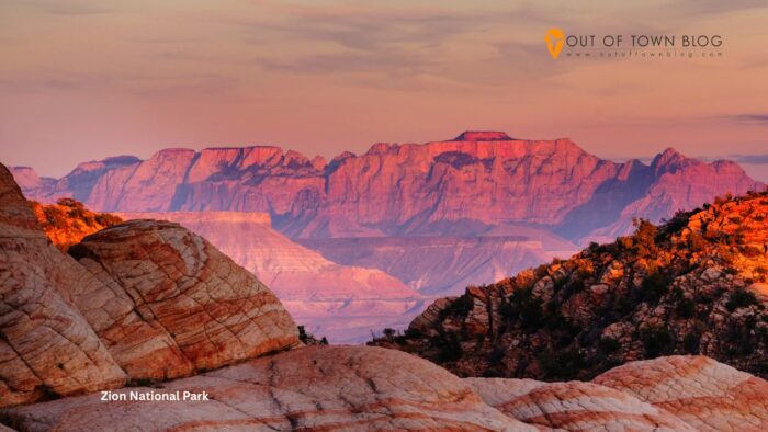
Zion National Park is famous for towering sandstone cliffs, narrow canyons, winding rivers, and striking red, cream, and orange rock formations. Located in southwestern Utah, the park combines dramatic desert scenery with areas of green vegetation and flowing water.
The main canyon contains many of Zion’s most recognizable views. The Virgin River runs through the valley beneath steep canyon walls, while scenic overlooks reveal layers of erosion-shaped sandstone. The Riverside Walk offers an accessible introduction to the canyon landscape, and other established trails provide different perspectives depending on conditions and visitor experience.
Spring and fall are often comfortable seasons for sightseeing. Spring brings flowing water and fresh vegetation, while fall offers cooler temperatures and changing colors in some areas. Summer can be very hot, and winter may bring icy conditions or snow at higher elevations.
Photographers can capture the canyon’s scale from designated viewpoints or focus on the sandstone’s textures and colors. Morning and late-afternoon light can reveal the cliffs’ contours, but this guide’s key seasonal advice is to prioritize spring and fall for more comfortable outdoor conditions.
Getting there: Las Vegas and Salt Lake City are major air gateways for the wider region, with driving connections to the park. Springdale sits near the main entrance, and seasonal shuttle systems may serve parts of the park.
Travel tip: Bring enough water and check trail conditions before you go. Desert heat, flash-flood risks, and steep terrain can make seemingly short outings demanding.
10. Chicago, Illinois
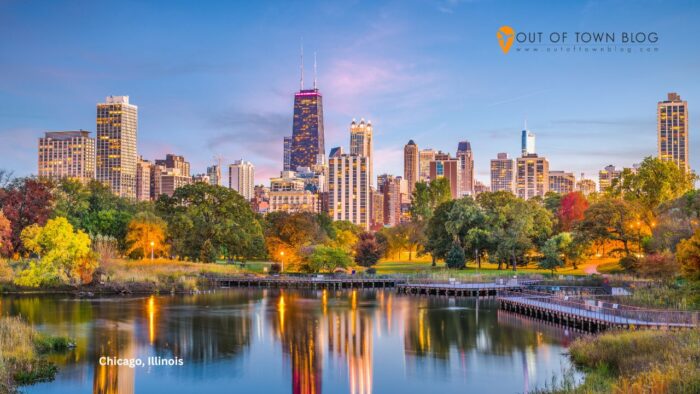
Chicago stands out for its architecture, lakefront setting, parks, and skyline. Beside Lake Michigan, the city blends impressive modern buildings with historic neighborhoods and open public spaces. Its waterfront gives the urban landscape a sense of scale unlike many other large American cities.
The Chicago Riverwalk offers views of downtown buildings from the water’s edge, while Millennium Park features public art and landscaped spaces. Architectural boat tours offer another way to take in the skyline and learn about its buildings. Along the lakefront, beaches and parks offer space to walk, cycle, and relax by the water.
Summer is a popular season for lakefront activities, outdoor festivals, and river cruises. Spring and fall can offer pleasant temperatures and changing colors in the parks. Winter brings colder weather and occasional snow, but the city’s architecture and museums remain appealing.
For photography, you can capture the skyline from lakefront parks, river bridges, and designated observation areas. Reflections on the Chicago River and Lake Michigan can add depth to cityscape images. Cloudy days can also soften light on glass-and-steel buildings.
Getting there: Chicago is served by O’Hare International Airport and Midway International Airport. Rail connections link the city with other major U.S. destinations, while local public transportation makes it practical to explore without a rental car.
Travel tip: Use public transit and walk where practical in the central city. Allow extra travel time during rush hour and major events.
11. Door County, Wisconsin
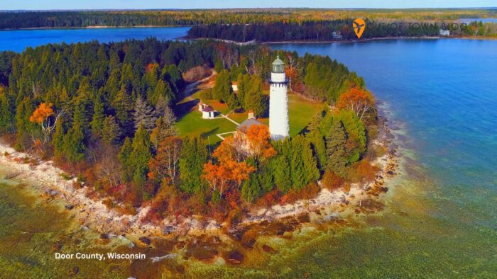
Door County is a scenic peninsula between Green Bay and Lake Michigan. It is known for its shoreline, small towns, lighthouses, orchards, wooded parks, and waterfront views. The region offers a quieter landscape than the country’s major coastal destinations, with a mix of rocky shores, sandy beaches, and charming communities.
The peninsula’s state parks and shoreline areas offer limestone cliffs, forests, and lake views. Historic lighthouses add character to the landscape, while small towns feature local shops, galleries, and waterfront dining. Seasonal orchards and farm stands provide another reason to explore the area during warmer months.
Summer is popular for boating, beach visits, and outdoor activities. Fall brings colorful foliage and a quieter atmosphere in many areas. Spring can be peaceful, although some businesses and visitor services may operate on reduced schedules before the summer season.
Photography subjects include lighthouses, harbor scenes, tree-lined roads, and sunsets over the water. In autumn, the contrast between colorful foliage and the blue lake can create particularly appealing images.
Getting there: Green Bay is a common gateway, with road connections leading north to the peninsula. Driving is generally the most flexible way to visit multiple communities and shoreline areas. Public transport options are more limited than in major cities.
Travel tip: Check seasonal opening schedules before visiting in spring or late fall, especially if you plan to explore smaller communities and attractions.
12. Acadia National Park, Maine
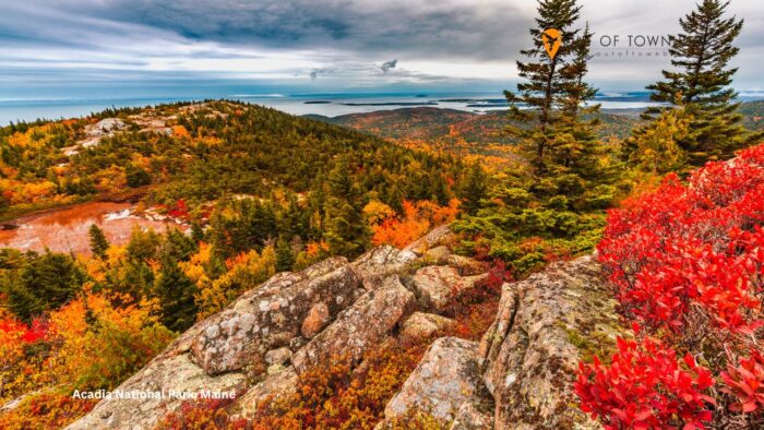
Acadia National Park combines a rocky Atlantic coastline, forested hills, granite peaks, and small islands along Maine’s coast. Its landscape blends ocean scenery with wooded terrain, with views across bays, offshore islands, and a rugged shoreline.
Mount Desert Island contains much of the park’s best-known scenery. Cadillac Mountain offers expansive views, while the Park Loop Road connects several coastal overlooks and access points. Sand Beach provides a sandy shoreline framed by rocky headlands, and the Ocean Path offers views of waves breaking against granite formations.
Summer brings warmer weather and more seasonal services. September and October are especially attractive for fall foliage, although the timing varies by year. Spring can be quieter, but weather may be cool, and some services may have limited schedules.
Photography opportunities include granite cliffs, coastal forests, rocky beaches, and broad ocean views. Autumn foliage adds color to the landscape, while overcast days can create strong contrast between the water and granite shore. Exposed coastal areas can be windy even in summer.
Getting there: Bangor International Airport is one gateway, while Portland and Boston provide additional flight options for a longer road trip. Driving helps you reach different parts of the park, and seasonal transportation services may operate from nearby communities.
Travel tip: Bring layers and rain protection. Coastal Maine can be cool and windy, particularly during spring and fall.
13. Newport, Rhode Island
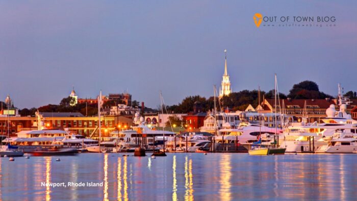
Newport is known for its historic mansions, coastal views, harbor, and elegant architecture. Set along the Rhode Island shoreline, the city combines New England charm with maritime history. Its grand historic homes and rocky coastal scenery make it one of the most visually distinctive small cities in the United States.
The Cliff Walk is one of Newport’s best-known attractions. It follows the coastline past ocean views and historic estates, offering a combination of natural scenery and architecture. The city’s harbor and historic streets offer more to explore, while the mansions showcase different architectural styles and Gilded Age details.
Late spring through early fall is generally the most comfortable time for coastal sightseeing. Summer brings lively waterfront activity and warm weather, while September and October can offer cooler temperatures and quieter streets. Winter has a different atmosphere, with fewer visitors and colder coastal conditions.
Photography subjects include the mansions, harbor views, rocky shoreline, and historic streets. The Cliff Walk offers several viewpoints where architecture and ocean scenery appear together. Be mindful of uneven paths and sections that weather may affect.
Getting there: Providence’s airport is the closest major air gateway, and Boston offers additional flight options. You can reach Newport by car, bus, and seasonal regional services, though options vary by departure point.
Travel tip: Wear comfortable walking shoes if you plan to explore the Cliff Walk and historic district. Some coastal sections have uneven surfaces and may not suit every visitor.
14. Shenandoah National Park, Virginia
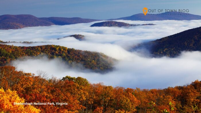
Shenandoah National Park protects a long stretch of the Blue Ridge Mountains in Virginia. Its scenery includes forested ridges, rolling valleys, rocky overlooks, and waterfalls. The park’s winding mountain roads offer broad views across the Appalachian landscape, making it a rewarding destination for scenic drives and nature photography.
Skyline Drive runs along the mountain crest and connects numerous overlooks. These viewpoints provide changing perspectives of forested hills and distant ridgelines. Waterfalls and wooded trails offer a closer look at the park’s landscape, while clear days can reveal long views across the Shenandoah Valley.
Spring brings fresh foliage and flowing streams. Summer provides lush greenery, although humidity and afternoon storms are possible. Fall is particularly popular for colorful leaves, generally from late September into October depending on elevation and yearly conditions. Winter can bring frost, snow, and road closures.
For photography, overlooks along Skyline Drive offer wide mountain panoramas, while forest trails provide close-up views of leaves, moss, and streams. Fall colors can vary by location, so exploring different elevations may reveal different stages of seasonal change.
Getting there: You can reach the park by road from Washington, D.C., and other Virginia communities. Regional airports serve the surrounding area, but driving is generally the most practical way to explore Skyline Drive and its overlooks.
Travel tip: Check road and weather conditions before setting out, especially during fall foliage season and winter, when closures can affect access.
15. Charleston, South Carolina

Charleston combines historic architecture, waterfront scenery, shaded streets, and a coastal atmosphere. Its historic district features pastel-colored buildings, churches, gardens, and traditional homes with distinctive porches and ironwork. The city’s visual appeal comes from the relationship between its architecture, tree-lined streets, and nearby waterways.
The historic district is a great place to start exploring Charleston’s character. Rainbow Row is one of its most photographed streets, while the waterfront provides open views across Charleston Harbor. Historic churches, public squares, and preserved residential streets show the city’s architectural variety.
Spring and fall are generally comfortable seasons for walking through the historic district. Spring brings flowering gardens and trees, while fall often offers milder weather than the hottest summer months. Summer can be hot and humid, and afternoon thunderstorms are possible.
Photography subjects include historic facades, shaded streets, waterfront views, and gardens. Early-day light can capture building details before streets get busier, while softer afternoon light can bring out the colors of historic homes.
Getting there: Charleston International Airport serves the city, and road connections link it with other southeastern destinations. The historic district is walkable in many areas, while local transit and taxis can help connect places farther apart.
Travel tip: Wear light, breathable clothing during warm months and carry water for longer walking routes. Allow additional time when visiting during major festivals or busy holiday periods.
16. Florida Keys, Florida
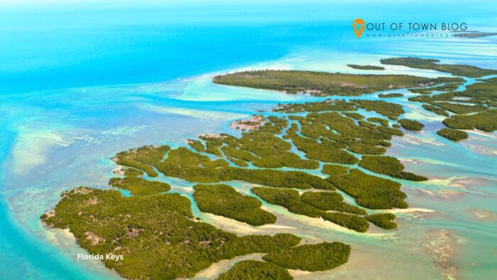
The Florida Keys form a chain of islands stretching southwest from mainland Florida into the Gulf of Mexico and Atlantic Ocean. The region is known for turquoise water, coral reefs, mangroves, small waterfront communities, and tropical vegetation. Its scenic appeal comes from island roads, ocean views, and access to marine environments.
The Overseas Highway connects many of the Keys through a series of bridges, creating a memorable road journey across open water. Key Largo is known for marine activities, while Islamorada has a strong fishing and boating culture. At the southern end of the island chain, Key West offers historic streets, waterfront views, and colorful architecture.
Winter and early spring offer warm weather and great outdoor activities. Summer is hot and humid, with higher chances of thunderstorms and tropical weather. Hurricane season runs from June through November, so travelers should monitor forecasts and remain flexible.
Photography opportunities include ocean views from the highway, palm-lined shorelines, boats in marinas, and sunset scenes. Clear water can create vivid images, although visibility varies with weather and sea conditions.
Getting there: Miami International Airport and Key West International Airport serve different parts of the region. Driving from mainland Florida is a popular option, while buses and shuttle services connect some communities. The Overseas Highway is the main road route.
Travel tip: Allow extra time to drive between islands, especially on busy weekends. Check weather conditions before planning boat trips or other water-based excursions.
17. New Orleans, Louisiana

New Orleans is one of the most distinctive cities in the United States, known for its historic architecture, lively streets, music culture, and distinctive neighborhoods. Its beauty lies in details like iron balconies, courtyards, colorful facades, and the Mississippi River’s curve.
The French Quarter contains many of the city’s best-known historic streets and buildings. Jackson Square is a central landmark, surrounded by historic architecture and views of St. Louis Cathedral. The Garden District offers another perspective, with large historic homes, mature trees, and landscaped streets.
Spring and fall are generally comfortable seasons for walking and exploring. Spring brings major festivals and lively street activity, while fall offers pleasant weather after the summer heat. Summer is hot and humid, and heavy rain is possible. Winter is usually milder than in many northern U.S. cities.
Photography subjects include wrought-iron balconies, colorful buildings, historic streetcars, and waterfront scenes. Architectural details are often easiest to photograph while walking through the older neighborhoods. Respect residents’ privacy when photographing homes and courtyards.
Getting there: Louis Armstrong New Orleans International Airport serves the city, and Amtrak and intercity buses provide other arrival options. Streetcars, buses, walking, and rideshare services can help visitors explore without a car.
Travel tip: Plan walking routes around the weather and neighborhood conditions. During major events, plan accommodations and transportation in advance.
18. Savannah, Georgia
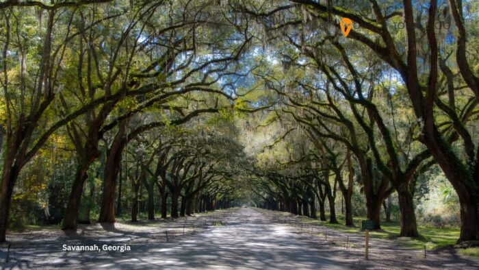
Savannah is known for its historic district, moss-draped oak trees, landscaped squares, and preserved architecture. Its streets combine brick sidewalks, historic homes, churches, and shaded public spaces. The city offers a quieter and more intimate visual experience than many large urban destinations.
The historic district centers on a network of public squares, each with its own character. Forsyth Park is one of the most recognizable green spaces, while River Street provides views of the Savannah River and historic commercial buildings. The city’s architecture includes traditional homes, churches, and preserved structures that reflect different periods of its history.
Spring and fall are generally pleasant seasons for sightseeing. Spring brings flowering trees and gardens, while fall often offers comfortable walking temperatures. Summer can be hot and humid, and mosquitoes may be noticeable in shaded or damp areas.
For photography, look for tree-lined streets, historic facades, park fountains, and riverfront scenes. Soft light beneath the oak trees can create distinctive images, while the squares offer a variety of architectural and landscape compositions.
Getting there: Savannah/Hilton Head International Airport serves the region. You can also get there by road, rail, and intercity bus. You can explore much of the historic district on foot, with local transit and taxis useful for longer distances.
Travel tip: Wear comfortable walking shoes and allow time to explore the public squares. The city’s compact historic core is best appreciated at a relaxed pace.
19. Badlands National Park, South Dakota
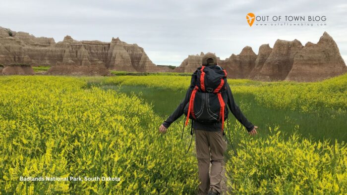
Badlands National Park features sharply eroded rock formations, layered cliffs, open grasslands, and broad prairie views. Located in southwestern South Dakota, the park’s landscape features colorful sedimentary layers shaped by wind and water. Its unusual formations stand in stark contrast to the surrounding grasslands.
The Badlands Loop Road connects many of the park’s main overlooks and provides views of spires, ridges, and deep gullies. Designated viewpoints let you appreciate the landscape without committing to long hikes. The park’s open terrain also offers opportunities to see wildlife, including bison and prairie dogs in appropriate areas.
Late spring and early fall are often comfortable times to visit. Spring can bring green grass and wildflowers, while fall typically offers cooler temperatures. Summer can be very hot and exposed, and winter may bring snow, wind, and difficult road conditions.
For photography, the layered rock formations become especially striking when low-angle sunlight emphasizes their colors and textures. Wide-angle views can capture the landscape’s scale, while closer compositions reveal the intricate patterns erosion creates.
Getting there: Rapid City Regional Airport is a common gateway, with road connections to the park. A rental car is generally the most convenient way to reach overlooks and travel along the Badlands Loop Road.
Travel tip: Carry water and sun protection, and avoid exposed terrain during thunderstorms. The landscape can appear open and easy to cross, but weather and footing can change quickly.
20. Mammoth Cave National Park, Kentucky
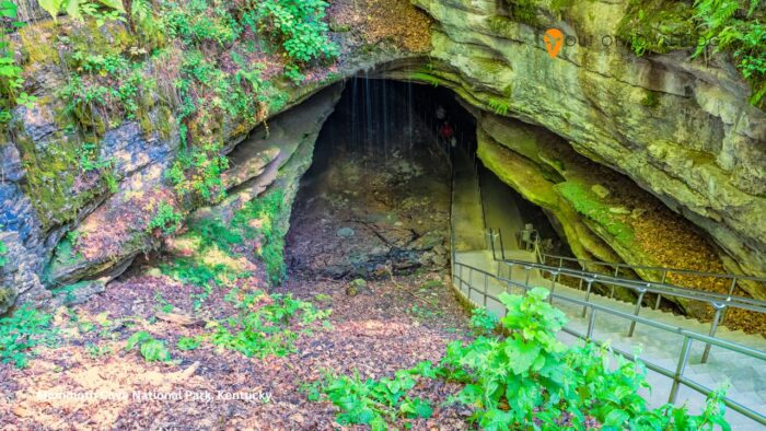
Mammoth Cave National Park offers a different kind of natural beauty. Beneath central Kentucky’s forests and rolling hills lies one of the world’s most extensive known cave systems. The park combines underground chambers, limestone formations, wooded trails, rivers, and historic sites.
The cave system is the main attraction. Guided tours reveal different sections of the underground landscape, from broad passageways to areas with distinctive geological features. Above ground, visitors can explore forested paths, river scenery, and quiet landscapes that change with the seasons.
Spring and fall are especially pleasant for exploring the park’s surface areas. Spring brings fresh vegetation and flowing streams, while fall adds color to the surrounding forests. Summer is warm and humid, but the cave environment remains much cooler than the surface. Winter can offer a quieter visit, although schedules and conditions may vary.
Photography inside the caves depends on tour rules and lighting, so visitors should check what is permitted before bringing equipment. Above ground, forest trails and river viewpoints provide opportunities for nature photography, particularly during spring greenery and autumn foliage.
Getting there: Louisville and Nashville are major regional airport gateways, with driving connections to the park. A car helps you reach visitor facilities and explore the surrounding area. Cave tours generally need to be planned around available schedules.
Travel tip: Choose a cave tour that matches your comfort with stairs, walking distances, and enclosed spaces. Wear sturdy shoes and bring a light layer for the cooler underground environment.
Frequently Asked Questions About the Most Beautiful Places in the U.S.
1. What are the most beautiful places in the U.S.?
Some of the most beautiful places in the U.S. include the Grand Canyon, Yosemite National Park, Na Pali Coast, Glacier National Park, Acadia National Park, and the Florida Keys. These destinations offer very different landscapes, from desert cliffs and alpine mountains to tropical coastlines and rugged Atlantic shores. Beautiful cities such as Chicago, Charleston, Savannah, and Santa Fe also deserve consideration because of their architecture, waterfront settings, historic districts, and cultural character.
2. What is the prettiest place in America to visit?
There is no single answer because the prettiest place depends on the scenery you enjoy most. The Grand Canyon is an exceptional choice for vast geological landscapes, while Yosemite offers granite cliffs and waterfalls. The Na Pali Coast is known for tropical green cliffs and ocean views, and Acadia combines forests with a rocky coastline. For architecture and city scenery, Charleston and Savannah offer historic streets and distinctive buildings. Each destination offers a different visual experience.
3. What are the best states to visit for beautiful scenery?
Hawaii, Alaska, California, Utah, Montana, Oregon, Maine, and Arizona are excellent choices for scenic travel because they offer distinctive landscapes and outdoor attractions. Hawaii has tropical coastlines, Alaska features glaciers and rugged mountains, and California combines dramatic national parks with a long coastline. Utah is known for red-rock formations, while Maine offers rocky shores and forested islands. Arizona’s desert landscapes and the Grand Canyon are among the country’s most recognizable natural attractions.
4. What is the best time of year to visit the most beautiful places in the U.S.?
Spring and fall are often good travel seasons because temperatures are more comfortable in many parts of the country. However, the ideal time depends on the destination. Summer is important for accessing many high-elevation areas in Alaska, Montana, and California, while winter can be appealing in warmer destinations such as New Orleans and the Florida Keys. Fall foliage is a major attraction in New England and the Appalachian region. Always consider regional weather, seasonal road access, and local operating schedules.
5. What are the best beautiful places in the U.S. for a road trip?
The Oregon Coast, the Florida Keys, Skyline Drive in Virginia’s Shenandoah National Park, and the scenic roads of Glacier National Park are strong road trip choices. These destinations offer memorable views along the journey, not just at the final stop. The Oregon Coast features ocean cliffs and beaches, while the Florida Keys connect islands through bridges over turquoise water. In mountain regions, road access can be seasonal, so check conditions before setting out and allow extra time for scenic stops.
6. What are the best coastal destinations in the United States?
The Oregon Coast, Na Pali Coast in Hawaii, Acadia National Park in Maine, Newport in Rhode Island, and the Florida Keys are among the country’s most scenic coastal destinations. Each offers a different environment. The Oregon Coast has rugged cliffs and sea stacks, while Hawaii features steep green mountains beside the Pacific. Acadia combines rocky shoreline with forested terrain, and Newport pairs ocean views with historic architecture. The Florida Keys are better known for warm water, island roads, and tropical marine scenery.
7. Which beautiful places in the U.S. are best for photography?
Yosemite, the Grand Canyon, Glacier National Park, Badlands National Park, and the N? Pali Coast are excellent choices for landscape photography. Their distinctive landforms, changing light, and seasonal conditions offer a wide range of compositions. For architecture and street photography, Chicago, Charleston, Savannah, and Santa Fe provide historic buildings, public spaces, and distinctive urban details. Plan around the season, weather, and access conditions rather than relying on a single viewpoint. Protect camera equipment from rain, wind, sand, and salt spray where relevant.
8. What are the best beautiful places in the U.S. for travelers who do not want strenuous hikes?
Chicago, Charleston, Savannah, Santa Fe, and Newport offer plenty of scenery without requiring demanding hikes. Many national parks also have overlooks, scenic roads, visitor areas, and shorter walking routes. The Grand Canyon’s South Rim has accessible viewpoints, while the Badlands Loop Road connects multiple scenic stops. In Yosemite, you can reach some valley viewpoints with limited walking. Accessibility varies by location, so check current facilities and path conditions if you need step-free routes, accessible parking, or other specific accommodations.
9. Are the most beautiful places in the U.S. expensive to visit?
Travel costs vary considerably depending on location, season, transportation, and accommodation choices. Major cities may offer public transit and a range of lodging options, while remote national parks often require a rental car and more advance planning. Popular coastal destinations can be especially busy during summer. Travelers can manage expenses by visiting during shoulder seasons, comparing transportation options, and planning their route efficiently. This article focuses on scenery and practical access rather than prices, so check current costs before making reservations.
10. Can I visit several of the most beautiful places in the U.S. on one trip?
Yes, but the best approach is to group destinations by region rather than trying to cover the entire country in one journey. For example, you could pair Yosemite with other California destinations, explore Charleston and Savannah together, or plan a New England trip centered on Maine and Rhode Island. Distances between some national parks are substantial, and mountain or coastal routes may take longer than expected. Choose a realistic geographic area, allow time for scenic stops, and avoid packing too many long drives into a short trip.
11. What should I pack when visiting beautiful destinations in the United States?
Pack for the climate and activities you plan for your destination. Comfortable walking shoes, layered clothing, a waterproof jacket, sun protection, and a reusable water bottle are useful for many trips. Mountain parks can be cold even in summer, while desert destinations may have intense heat and limited shade. Coastal areas can be windy, and tropical destinations may experience sudden rain. Bring photography equipment that suits your interests, but protect it from moisture, sand, and temperature changes. Check the local forecast shortly before departure.
12. How can I choose the best beautiful place in the U.S. for my next vacation?
Start by deciding which landscapes interest you most: mountains, beaches, deserts, historic cities, or coastal towns. Then consider the season, how much time you have, transportation options, and how much walking you prefer. Travelers seeking dramatic natural scenery might choose Yosemite, the Grand Canyon, or Glacier National Park, while those interested in architecture and historic streets may prefer Charleston, Savannah, or Santa Fe. Choose a destination that fits your travel style and schedule rather than selecting a place only because it is famous.
Conclusion: Discover the Most Beautiful Places in the U.S.
The most beautiful places in the U.S. reveal the country’s remarkable variety. From Yosemite’s towering cliffs and the Grand Canyon’s colorful formations to Charleston’s historic streets and the Florida Keys’ tropical waters, every destination offers a different reason to travel.
When planning your trip, consider the best season, travel time, and the scenery you most want to experience. Some places are ideal for a scenic road trip, while others reward a slower visit focused on architecture, coastal views, or nature photography.
Use this list of 20 beautiful places in America as a starting point for your next vacation. Which destination would you visit first, and what other beautiful place in the United States would you add to this list? Share your favorites and start planning your next U.S. travel adventure.
Want more updates about new package tours and tourist spots in the United States? Follow and subscribe to OutofTownBlog.com on Facebook, Twitter, Instagram, Pinterest, and YouTube for more USA travel and food-related updates.
Also read:
- 10 Best Hotels for Animal Lovers
- A step-by-step guide to visa processes and tips for Freelancers
- 10 of the Best Places to Visit in the United States

