

 Team Out of Town
Hong Kong Hikes: Discovering Sai Kung Beach Trails and Premier Island Hopping Routes
Who would have imagined that Hong Kong boasts its own hidden gems in the form of beach trails and adventure spots, catering to thrill-seeking travelers? The Sai Kung region, with its breathtaking coastal hiking paths and unspoiled beaches, is a true marvel. Here, dramatic mountain peaks rise majestically against the horizon, while crystal-clear turquoise waters stretch out like a shimmering carpet, framed by soft, white sand beaches that seem a world apart from the bustling urban landscape. This enchanting area serves as a natural playground, inviting hikers to traverse its rugged volcanic terrain and venture between secluded islands, each with its own unique charm and allure.
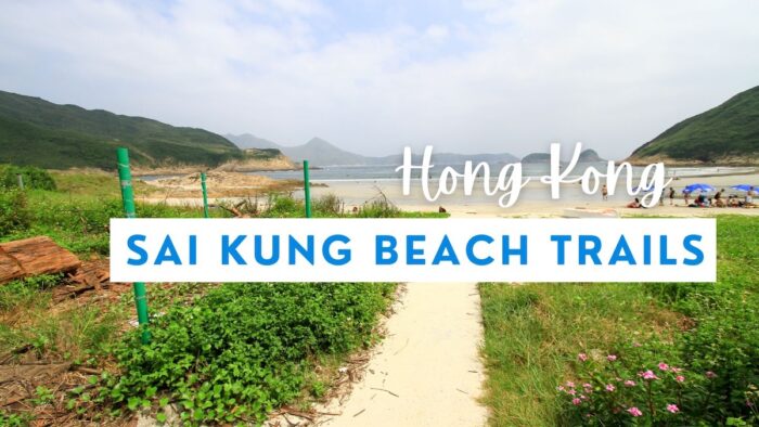
Sai Kung Beach Trails
Sai Kung offers an enchanting array of hiking trails that cater to every adventurer’s taste, from invigorating mountain ascents to serene strolls along picturesque beaches. This stunning region showcases remarkable landmarks, including the renowned Sharp Peak, known for its breathtaking vistas, and tranquil waterfront pathways that invite leisurely exploration. Adventurers can embark on unforgettable island-hopping excursions, venturing to secluded beaches and hidden coves just waiting to be discovered. With the added allure of UNESCO Geopark sites, visitors can immerse themselves in some of Hong Kong’s most awe-inspiring natural landscapes, making Sai Kung a treasure trove of outdoor beauty and adventure all in one remarkable location.
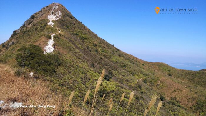
1) Sharp Peak Hike
Sharp Peak is considered one of Hong Kong’s most challenging hikes, located in Sai Kung East Country Park. The trail spans approximately 12 kilometers and takes between 5 to 6 hours to complete. Due to its difficulty, this trek is recommended only for experienced hikers, and local authorities advise against attempts by those lacking sufficient skills.
The summit offers breathtaking views of Sai Kung’s coastline and impressive ridges, with sights of the northeast mountains and beautiful beaches visible from the top.
There are two main routes to reach Sharp Peak. Hikers can start at Sai Wan Pavilion on the MacLehose Trail Stage 2, or take a speedboat to Ham Tin Wan Beach for easier access. The trail near Ham Tin is a 2.4-mile out-and-back route, which most hikers can complete in about 2 hours. This section is considered moderately challenging compared to the full climb of Sharp Peak.
Sharp Peak is situated north of Tai Long Wan’s beaches, an area that offers excellent photo opportunities and scenic views of the coastline. Hikers should ensure they are well-prepared for this strenuous adventure.
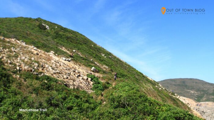
2) MacLehose Trail Section 1
MacLehose Trail Section 1 spans 10.6 kilometers from Pak Tam Chung to Long Ke, taking hikers through some of the most beautiful coastal areas of Sai Kung.
The trail begins at Pak Tam Chung and features a gentle slope for most of the route, allowing hikers to enjoy stunning views of the reservoir, which can appear glassy on calm days.
As the path winds through forests and along coastlines, white-sand beaches emerge after hikers climb small hills, offering opportunities to rest and take in ocean views.
This section typically takes about 3 hours to complete for most hikers. While the trail has a few ups and downs, it remains manageable for beginners.
Along the way, hikers pass remote villages where they can purchase refreshing coconut juice, offering a serene escape from the busy city.
The coastal views change as walkers progress, with some areas featuring lookout points that offer impressive views over Sai Kung’s many islands and bays.
Section 1 connects seamlessly with Section 2 for those who wish to extend their hike. The trail ends at Long Ke, where hikers can catch a ride back or continue along the MacLehose Trail.

3) High Island Geo Trail
The High Island Geo Trail showcases some of Hong Kong’s most impressive volcanic rock formations, which were formed 140 million years ago during a supervolcano eruption in the area.
This short loop trail is 1.2 miles long and takes about 34 minutes to complete. Most hikers find it easy to navigate because it has few elevation changes.
Along the trail, visitors can observe massive hexagonal rock columns created by ancient volcanic activity. These six-sided stone pillars line the coastline like natural sculptures.
The trail begins at the High Island Reservoir East Dam in Sai Kung East Country Park. Hikers follow marked paths to several viewpoints overlooking the rock formations.
The Po Pin Chau Section offers views of eroded volcanic columns and Kim Chu Wan pebble beach, as well as elevated viewpoints of the East Dam and High Island Reservoir.
In the Biu Tsim Kok Section, there is a hilltop viewing point that offers panoramic views. From this vantage point, hikers can see the ancient caldera and the white-sand beach of Long Ke Wan.
This trail is part of the UNESCO Global Geopark in Hong Kong, which preserves world-class geological features, including sea caves and rock islands sculpted by millions of years of erosion.
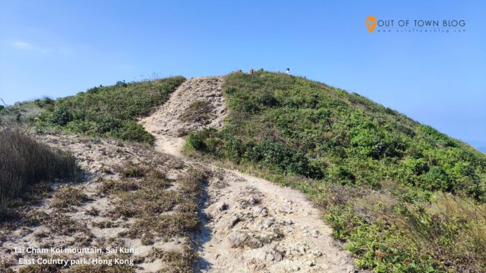
4) Sai Kung East Country Park Trails
Sai Kung East Country Park offers some of the best hiking experiences in Hong Kong. Designated in 1978, the park covers a large area of the eastern Sai Kung Peninsula.
The park features the highest number of bays and coves in Hong Kong, with access to four famous beaches: Tai Wan, Tung Wan, Sai Wan, and Ham Tin Wan. The MacLehose Trail runs through this area, with Sections 1 and 2 providing excellent views of High Island’s unique hexagonal volcanic columns, making the hikes especially scenic.
Sharp Peak is one of the most dramatic mountains in the territory, attracting local hikers and trail runners to its challenging terrain. The park is known for its rugged coastlines and clear jade-colored waters, offering trails that present stunning views of the South China Sea and the surrounding countryside.
With trails suited for varying hiking abilities, the park’s extensive network connects beaches, mountains, and scenic viewpoints. Popular starting points for hikers include High Island Reservoir and Wong Shek Pier. The diverse landscape features both coastal paths and mountain trails, providing a wide range of hiking experiences.
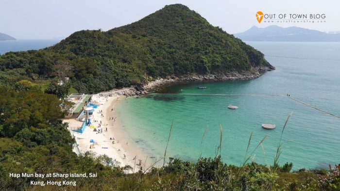
5) Hap Mun Beach Walk
Hap Mun Beach offers one of the most accessible coastal walks in Sai Kung. The trail connects two popular beaches on Sharp Island via a well-maintained path.
Visitors can reach the island by taking a ferry or private boat from Sai Kung town center, with the journey taking about 15 minutes.
The main trail spans 1.6 kilometers between Kiu Tsui Beach and Hap Mun Bay, allowing hikers to walk in either direction along this easy route. The path closely follows the coastline, and clear trail markers make navigation straightforward.
Hap Mun Bay features calm waters resembling a lagoon, making it an attractive spot for swimmers and families seeking a peaceful beach experience. The walk typically takes most people 30 to 45 minutes one way, as the terrain remains relatively flat with gentle slopes.
Sharp Island is part of Hong Kong’s UNESCO Global Geopark, where hikers can observe unique rock formations that date back 140 million years. This trail is suitable for beginners and families with children. Many visitors choose to combine the hike with time at the beach and swimming.
Barbecue facilities are available at Hap Mun Bay, and numerous groups enjoy spending the entire day hiking and participating in beach activities.
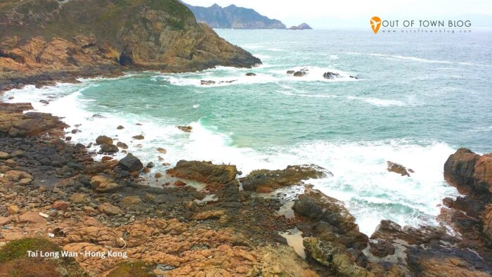
6) Tai Long Wan Beach Trail
The Tai Long Wan Beach Trail stretches approximately 12 kilometers along the eastern coast of Hong Kong. This popular hiking route takes visitors through four stunning beaches located in Sai Kung Country Park.
The trail begins at Sai Wan Pavilion in Sai Kung. Hikers can expect to see beautiful white sand beaches, clear blue water, and breathtaking coastal views.
The four main beaches along the trail are Sai Wan, Ham Tin Wan, Tai Wan, and Tung Wan. Each beach offers unique views and experiences of the coastline.
Most hikers complete this trail in about half a day. The path traverses rolling hills and marine landscapes, highlighting Hong Kong’s natural beauty. Sharp Peak, a dramatic backdrop for Tai Long Wan Beach, is the third stop on the route. Additionally, the area includes an old Hakka village that hikers can explore.
Transportation options make this hike accessible. Visitors can take a speedboat back to Sai Kung Pier from Ham Tin, Sai Wan, or Tai Long Wan beaches, rather than walking the entire loop.
The trail winds through untouched forests and offers access to some of the most transparent waters in Hong Kong’s coastal waters.
7) Coastal Hike in UNESCO Geopark
The Hong Kong UNESCO Global Geopark features one of the most breathtaking coastal hikes in the region. This trail takes hikers through remarkable rock formations formed 140 million years ago by a massive volcanic eruption.
The hike begins at the East Dam of the High Island Reservoir, located in Sai Kung East Country Park. From this point, hikers can admire the famous hexagonal columnar joints, which are among the most prominent volcanic rock formations of their kind in the world.
The coastal trail weaves along rugged coastlines and pristine beaches. Hikers will encounter towering sea arches and dramatic cliff faces, all shaped by ancient volcanic activity.
The route traverses wild landscapes that feel far removed from city life, with hidden beaches dotting the coastline, perfect for rest stops during the hike.
Most sections of this geopark trail are rated easy to moderate. The well-marked paths ensure straightforward navigation for hikers of all fitness levels.
Hikers can select from different route options based on their available time and energy. Some trails lead back to Sai Kung town, while others conclude at serene beachside locations.
This geopark hike highlights Hong Kong’s geological history within a stunning outdoor setting. On clear days, hikers can enjoy excellent views of the surrounding islands and coastline.
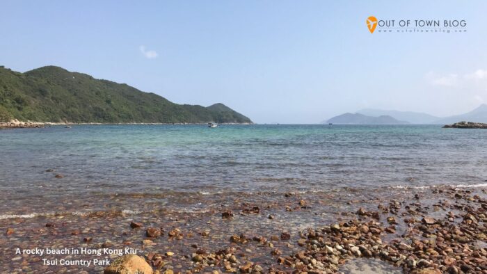
8) Kiu Tsui Chau Island Hopping
Kiu Tsui Chau, commonly known as Sharp Island, is located in the waters of Port Shelter in Sai Kung. This large island is part of Kiu Tsui Country Park.
Visitors can reach the island by boat from Sai Kung town, and the ferry ride offers scenic views of the coastline and surrounding waters.
Sharp Island features two main beaches: Kiu Tsui Beach, which serves as the primary landing point for most boats, and Hap Mun Bay Beach, located at the opposite end of the island.
Hikers can walk between the two beaches in about 90 minutes. The trail meanders through gentle hills and provides beautiful coastal views, making it suitable for families with children and older adults.
The island is a popular destination for fishing, swimming, and diving, with its waters remaining clear for most of the year. Unique rock formations formed by ancient volcanic activity embellish the landscape, showcasing intriguing shapes along the shore.
Camping is allowed in designated areas, and basic facilities are available to support overnight stays for those who wish to extend their visit.
Boat services operate regularly during daylight hours, so visitors should check the return schedules to avoid being stranded after sunset.
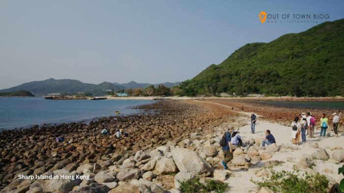
9) Sharp Island Exploration
Sharp Island is located just 2 kilometers from the Sai Kung town center and can be reached by a quick 15-minute boat ride from Sai Kung Pier.
The island offers several hiking trails that feature stunning coastal views. Hikers should check the tide times before setting out, as the path to Kiu Tau can become submerged during high tide.
Sharp Island consists of two small sections: Kiu Tsui and Kiu Tau. At low tide, these areas are connected by an underwater formation called a tombolo. Covering one square kilometer, Sharp Island is recognized as Hong Kong’s smallest island country park. The trails lead from Kiu Tsui Beach to the popular Hap Mun Bay.
Visitors can enjoy clear waters and pristine beaches, making it an ideal spot for swimming. The area also attracts diving and fishing enthusiasts year-round.
One of the island’s highlights is its unique volcanic rock formations, often called “Pineapple Bun” rocks, which add geological interest to beach walks. Families appreciate the easy hiking trails and the rock pools scattered along the coastline, making the island a perfect escape from city life with its lush greenery and expansive ocean views.
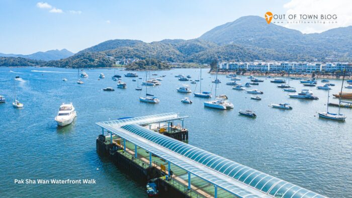
10) Pak Sha Wan Waterfront Walk
The Pak Sha Wan Waterfront Walk offers a peaceful coastal route that is ideal for families and casual hikers. This easy trail runs along the water’s edge in Sai Kung.
Hikers can enjoy clear views of the harbor and the surrounding islands. The path is mostly flat, with gentle slopes throughout.
The walk connects various points of the Pak Sha Wan Peninsula, and many visitors often combine this route with boat trips to nearby beaches. Trail maps show multiple starting points along the waterfront, with most people beginning near the Hebe Haven marina.
The concrete path makes walking easy in most weather conditions, and no special hiking gear is required for this route. Many hikers use this walk as part of longer adventures in Sai Kung, and it serves as an excellent warm-up before tackling more challenging trails.
The waterfront location offers great photo spots, allowing visitors to see both traditional fishing boats and modern yachts. Local restaurants and cafes are near the trail’s endpoints, making this walk suitable for half-day outings.
The route typically takes about 1 to 2 hours to complete, depending on the number of stops. Most people find it suitable for all fitness levels.
Frequently Asked Questions
What are the top-rated hiking trails in Sai Kung for beginners and experienced hikers alike?
Sai Kung, often called the “back garden of Hong Kong,” offers some of the city’s most scenic and diverse hiking trails — from easy coastal walks to steep mountain climbs. Here’s a breakdown of top-rated trails for both beginners and experienced hikers, based on recent 2025 reviews and guides from AllTrails, Localiiz, and Hong Kong Living.
Best Hiking Trails for Beginners
-
Sai Wan Pavilion to Sai Wan Beach
- Difficulty: Easy–Moderate
- Highlights: Gorgeous coastal views, white-sand beaches, and an optional detour to Sheung Luk Stream for waterfall swimming.
- Duration: ~1.5–2 hours one way
- Why it’s excellent: Well-marked path and easy access from Sai Kung Town.
-
Pak Lap Want to Ham Tin Beach
- Difficulty: Easy
- Highlights: Crystal-clear waters, coral reefs, and a relaxed beach vibe.
- Duration: ~1.5 hours
- Tip: Combine with a boat ride back to Sai Kung Pier for a scenic return.
-
High Island Reservoir East Dam
- Difficulty: Easy
- Highlights: UNESCO Geopark rock formations, sea caves, and sweeping ocean views.
- Duration: ~1–1.5 hours
- Why it’s excellent: Flat, paved path suitable for families and casual walkers.
Best Hiking Trails for Experienced Hikers
-
Sharp Peak (Nam She Tsim)
- Difficulty: Hard
- Highlights: One of Hong Kong’s most iconic summits with 360° views of Tai Long Wan and the Sai Kung Peninsula.
- Duration: ~5–6 hours round trip
- Tip: Best hiked in cooler months; steep and slippery descent.
-
MacLehose Trail Section 2
- Difficulty: Moderate–Hard
- Highlights: Combines beaches, forests, and ridgelines; passes through Sai Wan and Ham Tin Beaches.
- Duration: ~4–5 hours
- Why it’s great: A classic Sai Kung route with diverse scenery.
-
Po Pin Chau and High Island Geo Trail
- Difficulty: Moderate
- Highlights: Striking sea stacks, hexagonal rock columns, and dramatic cliffs.
- Duration: ~3 hours
- Tip: Bring water and sun protection—there’s little shade.
-
Tai Tun Shan
- Difficulty: Moderate–Hard
- Highlights: Panoramic views of Sai Kung Town and Sharp Island.
- Duration: ~3–4 hours
- Why it’s excellent: Less crowded but equally rewarding.
Can you list the essential items to pack for a Sai Kung beach trail adventure?
Here’s a comprehensive packing list to ensure you’re prepared for both the hike and beach experience:
Hiking Essentials
Footwear & Clothing
- Sturdy hiking shoes or trail runners – Essential for rocky, uneven terrain.
- Comfortable, moisture-wicking clothing – Breathable fabrics for Hong Kong’s humid climate
- Layers – A light jacket or windbreaker for changing weather conditions
- Hat or cap – Sun protection on exposed coastal paths
- Sunglasses – Strong sun reflection off water and rocks
Hydration & Nutrition
- Plenty of water (2-3 liters recommended) – Limited water sources on remote trails
- Snacks & energy bars – Trail mix, fruit, sandwiches for longer hikes
- Electrolyte drinks – Essential in summer heat
Navigation & Safety
- Trail map or GPS app (AllTrails, Maps.me) – Cell service can be spotty
- Fully charged phone + portable charger
- First aid kit – Band-aids, antiseptic, blister treatment
- Whistle – Emergency signaling
- Headlamp or flashlight – In case you’re out later than planned
Beach-Specific Items
Swimming & Water Activities
- Swimsuit – Many Sai Kung beaches (Ham Tin, Tai Long Wan, Long Ke) are perfect for swimming.
- Quick-dry towel – Compact and lightweight
- Snorkeling gear (optional) – Clear waters at Ham Tin and Pak Lap Wan
- Waterproof bag or dry sack – Protect electronics and valuables
- Beach sandals or water shoes – For rocky shorelines
Sun Protection
- High SPF sunscreen (reef-safe preferred) – Reapply frequently
- After-sun lotion or aloe vera – Soothing for sunburn
- Lip balm with SPF
Additional Gear
Backpack Essentials
- Lightweight daypack (20-30L) – Comfortable for 4-6 hour hikes
- Trash bags – Pack out all waste (Leave No Trace principles)
- Insect repellent – Mosquitoes can be present near forested areas
- Wet wipes or hand sanitizer – Limited facilities on remote beaches
- Cash – For bus/minibus fare, boat rides, or village stores in Sai Kung Town
Optional but Useful
- Trekking poles – Helpful on steep sections like Sharp Peak
- Camera or action cam – Capture stunning coastal views
- Waterproof phone case – For photos near water
- Change of clothes – Fresh shirt and socks for the journey home
- Small cooler or insulated bag – Keep drinks cold (if you have space)
Transportation Tips
- Octopus card – For MTR, buses (Routes 94 from Diamond Hill, 96R on weekends)
- Ferry/speedboat fare – Some beaches, like Long Ke Wan, are accessible by boat from Sai Kung Pier.
Important Reminders
- Check weather forecasts – Avoid hiking during typhoon warnings or heavy rain
- Start early – Beat the heat and crowds (aim for 8-9 AM departure)
- Tell someone your plan – Share your route and expected return time
- Respect nature – No littering, avoid disturbing wildlife, stay on marked trails
Where to Stock Up Before You Go
- Sai Kung Town: Supermarkets, bakeries, and outdoor gear shops near the waterfront
- Pak Tam Chung Visitor Centre: Last stop for water/snacks before trailheads
How does one reach the starting points of Sai Kung’s remote hiking trails by public transportation?
Getting to Sai Kung’s remote trailheads requires a combination of MTR, buses, minibuses, and sometimes boats. Here’s a comprehensive guide based on current transportation options:
Step 1: Get to Sai Kung Town
From Central Hong Kong
- MTR to Diamond Hill Station (Kwun Tong Line – green line)
- Take Bus 92 from Diamond Hill to Sai Kung Town (~40 minutes)
- Alternative: Green minibus 1A (faster, but can be crowded)
From Kowloon
- Bus 92 from Diamond Hill
- Bus 96R from Diamond Hill (Saturdays, Sundays, and public holidays only)
- Bus 299X from Sha Tin
Step 2: From Sai Kung Town to Trail Starting Points
1. High Island Reservoir East Dam (for Sharp Peak, MacLehose Trail Section 2)
Option A: Bus
- Bus 94 from Sai Kung Town to Pak Tam Au bus stop
- Frequency: Every 15-30 minutes on weekdays, more frequent on weekends
- Journey time: ~30 minutes
- From Pak Tam Au, you can:
- Hike to High Island Reservoir East Dam (~1 hour walk)
- Access MacLehose Trail Section 2
Option B: Taxi
- Taxi from Sai Kung Town to High Island Reservoir East Dam: ~HKD 100-120
- Recommended if hiking in a group to split costs
- Saves 1+ hour of walking
High Island Geo Trail – Biu Tsim Kok Section
Bus Options:
- Bus 94 (daily service)
- Bus 96R (Saturdays, Sundays, and public holidays only)
- Bus 289R (Saturdays, Sundays, and public holidays only)
Getting There:
- Alight at Sheung Yiu bus stop
- Walk along Tai Mong Tsai Road to the junction
- Turn right onto Sai Kung Man Yee Road
- Continue to the trail starting point
3. Ham Tin Beach & Tai Long Wan Beaches (for Sharp Peak, beach hikes)
Option A: Hike In
- Take Bus 94 to Pak Tam Au
- Hike MacLehose Trail Section 1 to Ham Tin (~3 hours, relatively easy)
Option B: Speedboat (Most Popular for Remote Beaches)
- From Sai Kung Pier to Ham Tin Wan, Sai Wan, or Long Ke Wan
- Cost: HKD 60-80 per person (one way), ~15-20 minutes
- Boat operators have signs at the pier saying “Sai Wan,” “Ham Tin Wan,” etc.
- Return boats: Usually available until late afternoon (4-5 PM)
- Tip: Negotiate round-trip pricing or confirm return boat times before departing
4. Tai Tan Country Trail (Hoi Ha Wan area)
No Direct Public Transport to the starting point deep in Sai Kung Country Park
Options:
- Taxi from Sai Kung Town to Tai Tan or Hoi Ha Road (~HKD 80-100)
- Green minibus 7 from Sai Kung Town to Hoi Ha Village (limited service, mostly weekends)
- Bus 94 to a closer stop, then taxi/hike the remaining distance.
Boat Services from Sai Kung Pier
Available Routes
Popular destinations from Sai Kung Public Pier:
- Ham Tin Wan (Ham Tin Beach)
- Sai Wan (Sai Wan Beach)
- Long Ke Wan (Long Ke Beach)
- Tap Mun Island (Grass Island)
How to Arrange
- Walk to Sai Kung Public Pier (near the waterfront)
- Look for kaito (small ferry) operators with destination signs
- No fixed schedule – boats leave when full (usually 8-12 passengers)
- Busiest times: Weekends and public holidays (arrive early, 8-9 AM)
Return Journey
- Arrange pickup time with the boat operator, OR
- Flag down passing boats at the beach (less reliable)
- Last boats typically leave beaches by 4-5 PM
Bus Schedule Tips
Weekend-Only Routes
- 96R and 289R operate Saturdays, Sundays, and public holidays only
Peak Hours
- Buses to/from Sai Kung fill up quickly on weekends (8-10 AM outbound, 4-6 PM return)
- Arrive early or consider hiking on weekdays for quieter trails
Pro Tips for Public Transportation
- Octopus Card is Essential – Works on MTR, buses, minibuses, and some ferries
- Check Real-Time Bus Arrivals – Use apps like Citymapper or KMB/LWB Mobile App
- Plan Return Transportation – Last buses from remote areas (Pak Tam Au) leave around 7-8 PM
- Taxi Apps – HKTaxi or Uber work in Sai Kung Town, but the signal may be weak at trailheads
- Group Taxi Sharing – Post in hiking Facebook groups to split taxi costs to remote starts
Summary: Getting to Popular Trails
| Trail/Destination | Transportation | Estimated Cost | Time from Sai Kung Town |
|---|---|---|---|
| High Island Reservoir East Dam | Bus 94 to Pak Tam Au + hike OR taxi | HKD 10-120 | 30-60 min |
| Sharp Peak (via Ham Tin) | Speedboat from the pier | HKD 60-80 | 15-20 min |
| High Island Geo Trail | Bus 94/96R/289R to Sheung Yiu | HKD 10-15 | 30 min |
| Tai Tan Country Trail | Taxi or minibus 7 (limited) | HKD 80-100 | 25-35 min |
| Sai Wan Beach | Speedboat from the pier | HKD 60-80 | 15-20 min |
What safety precautions should hikers take when exploring isolated trails in Hong Kong?
Here are essential precautions for hiking isolated trails safely:
Before You Go: Planning & Preparation
1. Route Planning
- Choose well-maintained trails with clear directional signs, especially if you’re inexperienced
- Familiarize yourself with the area, including:
- Escape routes
- Transportation information
- Locations of police stations
- Country park ranger offices
- Emergency call telephones
- Check trail difficulty ratings and match them to your fitness level.
2. Weather & Conditions
- Check weather forecasts before departure
- Avoid hiking during:
- Typhoon warnings (T3 or above)
- Heavy rain or thunderstorms
- Extreme heat warnings (33°C+)
- Poor visibility or fog
- Hong Kong’s summer heat and humidity (May-September) can cause heat exhaustion.
3. Tell Someone Your Plans
- Share your hiking route and expected return time with family/friends
- Leave contact information for emergencies
- Check in upon return
Essential Safety Gear
Navigation & Communication
- Fully charged mobile phone + portable charger
- Downloaded offline maps (AllTrails, Maps.me) – cell signal can be weak on isolated trails
- Whistle for emergency signaling (3 short blasts = distress signal)
- Headlamp/flashlight with extra batteries
First Aid & Emergency
- Comprehensive first aid kit including:
- Bandages and gauze
- Antiseptic wipes
- Blister treatment
- Pain relievers
- Insect bite cream
- Any personal medications
- Emergency blanket (space blanket)
Hydration & Nutrition
- Carry sufficient water (2-3 liters for full-day hikes)
- High-energy snacks – isolated trails have no facilities
- Electrolyte replacement drinks or tablets
During Your Hike: Safety Practices
1. Stay on Marked Trails
- Don’t take shortcuts or attempt off-trail routes
- Follow trail markers and directional signs
- Respect warning signs about dangerous areas
2. Pace Yourself
- Start early (7-9 AM) to avoid afternoon heat and ensure daylight return
- Take regular breaks – don’t push beyond your limits
- Turn back if conditions worsen or you’re running late
- Hong Kong’s terrain can be deceptively challenging – steep ascents/descents are common
3. Group Safety
- Never hike alone on isolated trails if possible
- Stay together as a group – don’t let anyone lag far behind
- Establish meeting points if the group splits
4. Wildlife & Environmental Hazards
- Watch for:
- Wild boars (don’t feed or approach)
- Snakes (especially in summer) – wear long pants, watch where you step
- Monkeys (don’t show or offer food)
- Poisonous plants
- Stay back from cliff edges – Hong Kong’s coastal trails can have unstable terrain
- Be cautious near waterfalls and streams – slippery rocks, flash flooding during rain
Emergency Procedures
If You Get Lost or Injured
1. Stay Calm and STOP
- Stop – Don’t wander further
- Think – Assess your situation
- Observe – Look for landmarks, trail markers
- Plan – Decide on the safest course of action
2. Call for Help
- Emergency number: 999 (works even without a cell signal if any network is available)
- Provide your location:
- GPS coordinates (use phone’s GPS)
- Nearby landmarks
- Trail name and direction you were heading
- Number of people in your party
- Nature of the emergency
3. Use Emergency Call Boxes
- Hong Kong has emergency call telephones at strategic points in the country parks
4. Signal for Help
- Whistle: 3 short blasts repeatedly
- Use a phone flashlight to signal at night
- Wear bright clothing to attract attention
- Stay visible – move to open areas if safe
Useful Emergency Contacts
| Service | Number | When to Use |
|---|---|---|
| Emergency (Fire/Ambulance/Police) | 999 | Life-threatening situations |
| Country Parks Hotline | 1823 | Non-emergency park inquiries |
| Hong Kong Observatory | 187 8200 | Weather information |
| GovHK Hiking Safety Info | Visit gov.hk | Pre-hike planning |
Heat-Related Illness Prevention
Warning Signs of Heat Exhaustion
- Heavy sweating
- Weakness or fatigue
- Dizziness
- Nausea
- Headache
- Muscle cramps
What to Do:
- Move to shade immediately
- Drink water slowly
- Cool the body with wet cloths
- Seek medical help if symptoms worsen
Heat Stroke (Medical Emergency)
- High body temperature (40°C+)
- Confusion or altered mental state
- Hot, dry skin (sweating stops)
- Call 999 immediately
Trail-Specific Hazards
Hong Kong’s Most Dangerous Trails
Recent government reports highlight increased accidents on challenging routes, including:
- Sharp Peak (Sai Kung) – Steep, slippery descents
- Dragon’s Back – Exposed ridgelines
- Sunset Peak (Lantau) – Rocky, uneven terrain
- Kau Nga Ling – Technical scrambling required
The Hong Kong government has strengthened safety measures following a rise in accidents involving inexperienced or ill-equipped hikers in 2025
Pre-Hike Safety Checklist
- Weather forecast checked
- Trail difficulty matches fitness level
- Route and escape routes studied
- Someone knows your plans and expected return
- Phone fully charged + portable charger packed
- Sufficient water (2-3L) and food
- First aid kit and emergency supplies
- Appropriate footwear and clothing
- Sun protection (hat, sunscreen, sunglasses)
- Headlamp/flashlight with extra batteries
- Whistle for emergencies
- Offline maps downloaded
Leave No Trace Principles
- Pack out all trash – no littering
- Stay on designated trails – protect vegetation
- Don’t disturb wildlife – observe from a distance
- Respect other hikers – yield on narrow paths
- No open fires – hazardous and illegal in country parks
Official Resources
- GovHK – Hiking Tips – Government hiking safety guidelines
- AFCD Safety Guidelines – Country Park Safety Information
- LCSD Hiking Scheme – Safety hints and trail information
- Hong Kong Observatory – Real-time weather updates
Remember: Most hiking accidents in Hong Kong result from:
- Poor planning and underestimating trail difficulty
- Inadequate gear (especially footwear and water)
- Ignoring weather warnings
- Overestimating fitness levels
- Hiking alone on remote trails
When in doubt, turn back. No summit or destination is worth risking your safety!
Which islands offer the best island-hopping experiences and pristine beaches near Hong Kong?
Sharp Island features two main beaches and connects to Bridge Island during low tide. The island is part of the UNESCO Hong Kong Geopark, home to unique rock formations.
Kiu Tsui Beach on Sharp Island offers calm waters perfect for swimming. The volcanic coastline creates natural tidal pools for exploration.
Po Pin Chau sea stack provides dramatic photo opportunities near High Island. Boats can approach this towering rock formation during calm weather.
Jin Island connects to the mainland via a concrete bridge. The small island offers easy walking paths and fishing spots.
Are there any permit requirements or conservation rules to be aware of when visiting Hong Kong’s island beaches?
No special permits are required for hiking trails in Sai Kung Country Parks. All trails remain open to the public year-round during daylight hours.
Camping requires permits from the Agriculture, Fisheries, and Conservation Department. Designated campsites operate in Sai Kung East Country Park with advance booking.
Visitors must pack out all trash from beaches and trails. Littering in country parks carries fines of up to HK$1,500.
Fires are prohibited except in designated barbecue areas with proper facilities. Collecting shells, corals, or rocks from beaches violates conservation laws.
Hong Kong Travel Tour Packages You Should Try
Follow and subscribe to OutofTownBlog.com on Facebook , Twitter, Instagram, Pinterest, and YouTube for more Travel-related updates.
Read: